

Flow from Ash Meadows Groundwater Basin to Furnace Creek area
Handouts, posters, and KMZ of all four stops are in the ZIP file.
Abstract
The field trip will focus on regional flow to Ash Meadows and to the Furnace Creek area. Ash Meadows and the downgradient Alkali Flat-Furnace Creek Ranch (AFFCR) groundwater basin, where Furnace Creek is located, are hydraulically connected. About 40 percent of discharge from the Furnace Creek area is recharged in the Ash Meadows groundwater basin and is conceptualized to flow into basin fill in the central Amargosa Desert via the megachannel. The megachannel is a large, transmissive, carbonate, groundwater pool that can be drained easily but fills up slowly. An alternative conceptualization of flow from Ash Meadows to the Furnace Creek area assumes that groundwater from the Ash Meadows groundwater basin flows through deep carbonate rocks that extend between Ash Meadows discharge area and the southeastern Funeral Mountains. Lithology, hydraulic properties, chemical evidence, and numerical simulation results demonstrate that the basin-fill flow path is more likely than the deep-carbonate flow path.
Significant hydrologic features will be visited and discussed during the field trip. These features define flow from the Ash Meadows groundwater basin to the Furnace Creek area. Basin-fill and deep-carbonate flow path conceptualizations will be discussed at each stop. The field trip will begin at Furnace Creek Ranch and end near Crystal Springs at the Ash Meadows visitor center.
Four stops are detailed as follows:
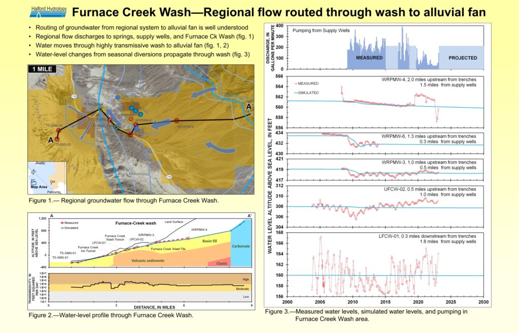
1.) Furnace Creek Wash above Travertine Springs,
An area where regional flow channels into Furnace Creek Wash. The transmissive nature of Furnace Creek wash sediments is illustrated by seasonal water-level changes in wells from seasonal diversions of water from the wash. Breaches in low-permeability clays above Travertine Springs are visible at the stop.
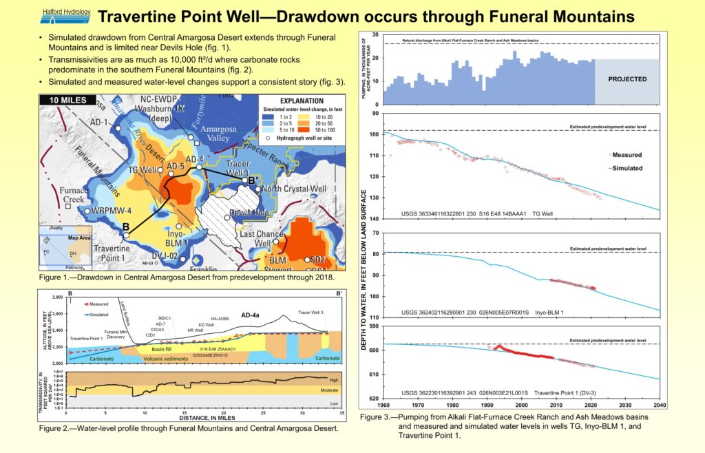
2.) Near Travertine Point 1 well,
Water levels have declined greater than 10 ft from regional pumping, which occurs greater than 10 miles northeast of stop 2. Annual pumpage from central Amargosa Desert totals just under 20,000 acre-ft, whereas annual pumpage near Furnace Creek averages less than 400 acre-ft (240 gal/min).
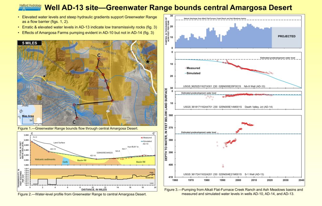
3.) Well AD-13 overlook,
Water-level altitude and fluctuations demonstrate Greenwater Range is a hydraulic barrier. Water-level rises of greater than 10 ft from negligible recharge volumes are consistent with low-permeability rocks. Water levels in well AD-13 are 300 ft higher than in well AD-14 at Death Valley junction, which shows water flows from the Greenwater Range towards basin fill beneath highway CA190.
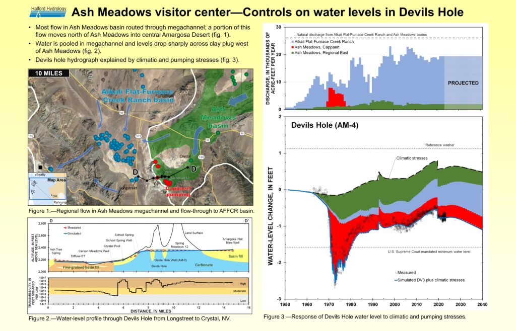
4.) Ash Meadows visitor center,
Long-term, natural fluctuations change water levels a bit more than 1 ft in Devils Hole and wells around Ash Meadows. Natural water-level changes are significant because local pumping effects are attenuated as drawdowns occur throughout the megachannel. Deep-carbonate flow path conceptualization unlikely where carbonate rocks displaced nearly a mile across Gravity fault and permeable carbonate rocks abut massive clay barrier.
Material presented during the 2023 Devils Hole field trip is documented fully in,
Halford, K.J., and Jackson, T.R., 2020, Groundwater characterization and effects of pumping in the Death Valley regional groundwater flow system, Nevada and California, with special reference to Devils Hole: U.S. Geological Survey Professional Paper 1863, 178 p., https://doi.org/10.3133/pp1863.
Field trip guides are,
Keith J. Halford, Halford Hydrology LLC, khalford@halfordhydrology.com, and
Joe M. Fenelon, U.S. Geological Survey (emeritus), jfenelon@usgs.gov